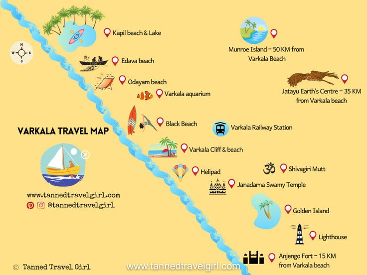
Varkala City Map

Varkala is located in the south Indian state of Kerala and is easily accessible from Thiruvananthapuram by road and rail. It has some amazing tourist attractions like the picturesque Varkala beach and the magnificent Janardhana swamy temple. It is also close to vacation destinations like Kodaikanal and Kovalam. This Varkala map shows the major tourist attractions and guides you as you explore important places to visit in and around Varkala.
HOW TO REACH VARKALA
Varkala is located in the state of Kerala and is well-connected with Thiruvananthapuram. Thiruvananthapuram in turn is accessible from all major parts of India by road, rail and air. Varkala is visited by several tourists all year round. Here is how to reach Varkala:
BY AIR
Nearest airport is at Thiruvananthapuram located around 45 km away from the beach town. It caters to over 40 international and national flights and over a thousand passengers every day. Flights connect Thiruvananthapuram to many major Indian cities like Delhi, Mumbai, Kochi (Cochin), Chennai, Bengaluru and Hyderabad. It is also connected by flight to several destinations in Middle East. Pre-paid taxis are available from the airport to Varkala.
BY TRAIN
Varkala lies on the rail line connecting Thiruvananthapuram to Ernakulam. However, all trains do not stop at the station. Thiruvananthapuram is the major rail head close to Varkala. Thiruvananthapuram is connected by rail to several Indian cities like Mumbai, Delhi, Chennai and Bengaluru. Taxis can be hired from the railway station to Varkala.
BY ROAD
The state-government run KSRTC plies buses regularly from Thiruvananthapuram. Tourists coming from Kochi can board a bus to Thiruvananthapuram and get down at Attingal to catch a connecting bus to Varkala. Buses can get crowded and the journey can get a tad tedious.
0 Comments